Upcoming Infrastructure Developments in East Bangalore
Register Your EOI Now / Book Your Site Visit
The upcoming infrastructure developments in East Bangalore are set to transform the area with significant road, transit, and regional connectivity projects that will support the city’s growth towards the east. This region, particularly the Whitefield–Varthur–Sarjapur Road corridor, is moving from a phase of peripheral expansion to a more structured approach to urban planning focused on infrastructure. For residential developments in this area, such as Abhee Codename New Dimension, these upgrades are vital for improving accessibility, streamlining commutes, and boosting long-term livability.
East Bangalore’s infrastructure strategy revolves around four major upgrades: the 150-ft CDP Road, the Peripheral Ring Road (PRR), the Satellite Town Ring Road (STRR), and the forthcoming Metro expansion. Collectively, these projects are designed to alleviate congestion, distribute traffic more effectively, and enhance daily mobility throughout Bengaluru.
150-ft CDP Road: Enhancing Local Connectivity Around the Project
A CDP (Comprehensive Development Plan) Road is an essential arterial road outlined in Bengaluru’s urban master plan, designed to facilitate smoother intra-city travel and improve last-mile access. The upcoming 150-ft CDP Road, situated near Abhee Codename New Dimension, is intended to be a wide, signal-friendly corridor that connects Varthur Road with Sarjapur Road and the surrounding neighborhoods.
From a functional viewpoint, this road enhancement offers:
- Improved entry and exit flow from the project area
- Enhanced access to nearby schools, healthcare services, and shopping districts
- A better distribution of traffic, helping to alleviate congestion on narrower internal roads
For those living in Abhee Codename New Dimension, the CDP Road will greatly enhance local mobility, making everyday travel more convenient and reducing the need to navigate through crowded junctions. Such roads are vital for residential developments, as they promote consistent commuting patterns and help ease traffic during peak times.
Peripheral Ring Road (PRR): Transforming Regional Travel Access
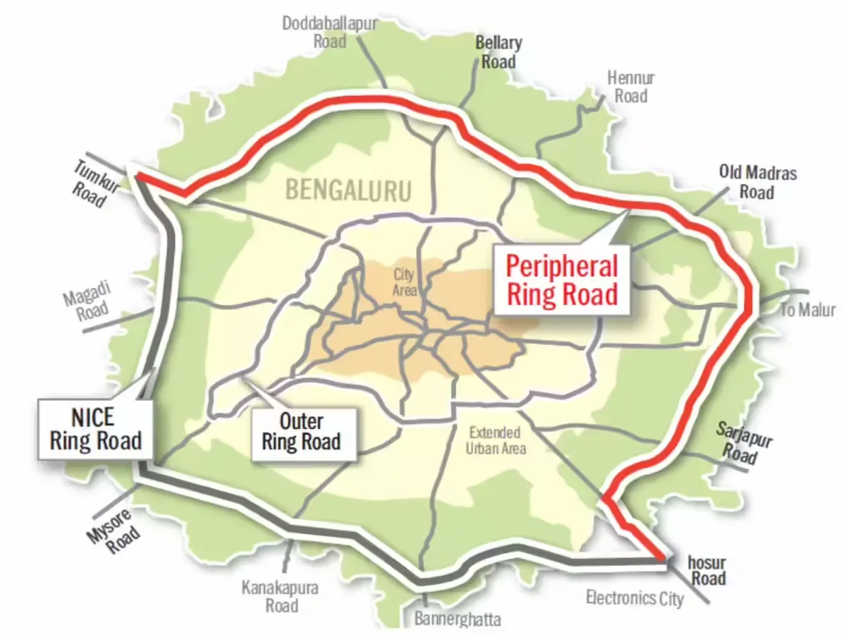
The Peripheral Ring Road (PRR) is set to be one of Bengaluru’s most important infrastructure projects on the horizon. Designed as a high-capacity ring road that extends beyond the Outer Ring Road (ORR), the PRR aims to redirect long-distance and freight traffic away from the bustling city center.
For those living along the Varthur–Sarjapur Road corridor, the PRR brings:
- Quicker travel between east and west, as well as north and south
- Less congestion on the ORR and at the Silk Board Junction
- Simpler access to key employment hubs throughout Bengaluru
From the perspective of Abhee Codename New Dimension, the PRR enhances regional connectivity, enabling residents to navigate different parts of the city without getting stuck in traffic jams. This is especially beneficial for professionals who work across various tech corridors or businesses that need to travel across the city.
Satellite Town Ring Road (STRR): Improving Long-Distance Connectivity
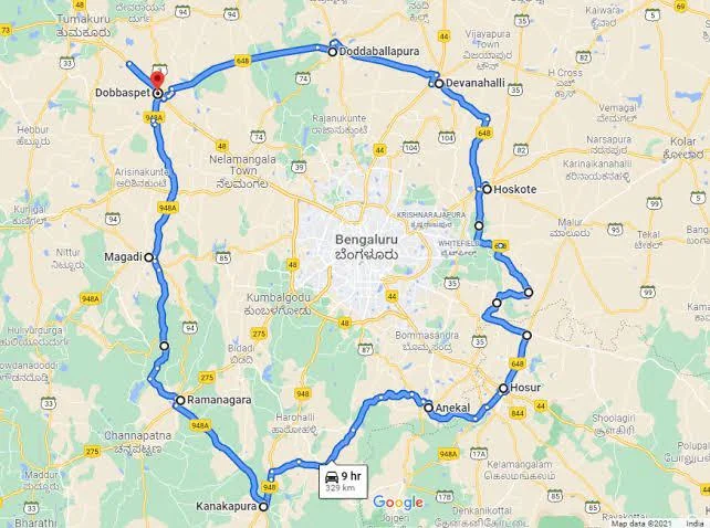
The Satellite Town Ring Road (STRR) is a state-level project aimed at connecting Bengaluru with its neighboring satellite towns, including Doddaballapur, Hoskote, Devanahalli, and Ramanagara. Unlike roads that cater mainly to city traffic, STRR is designed for inter-city travel and logistics.
For those considering residential developments in East Bangalore:
- STRR decreases the need to rely on city roads for long-distance trips
- Enhances access to industrial and growing economic zones
- Encourages balanced urban development beyond Bengaluru’s limits
When it comes to Abhee Codename New Dimension, STRR plays a crucial role in improving connectivity, making travel to satellite towns and nearby hubs much more efficient. This is particularly advantageous for families, business owners, and professionals whose travel extends beyond the traditional city boundaries.
Metro Expansion in East Bangalore: Future Public Transit Access
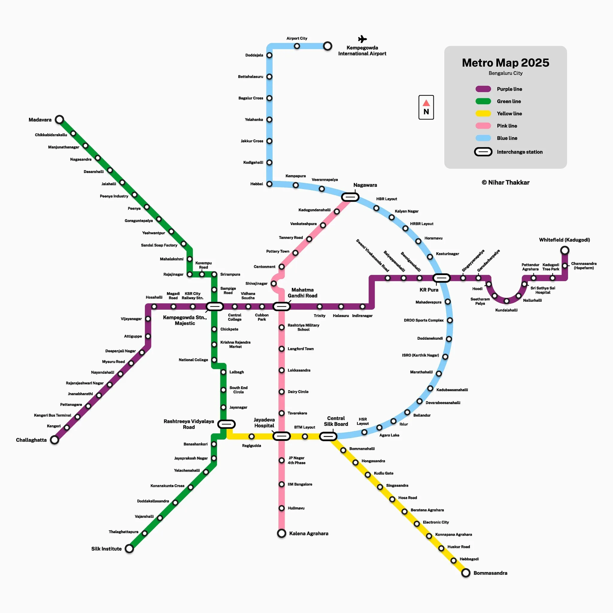
Bengaluru’s Metro network is on the rise, with planned phases aimed at enhancing mass rapid transit throughout the city. This includes new corridors that will significantly improve connectivity for the eastern and southeastern areas.
One of the standout proposals is the Sarjapur–Hebbal Metro corridor, commonly known as Phase 3A of the Namma Metro network. In December 2024, the Karnataka Cabinet gave the green light to this ambitious Rs 28,405 crore project, which will stretch about 36.6 km from Sarjapur in the southeast to Hebbal in the north, featuring multiple stations and interchanges.
- Starting as an elevated corridor from Sarjapur to Iblur/Koramangala, the alignment will then transition underground as it travels through central Bengaluru, finally emerging at Hebbal.
- The proposed line will connect with current Metro corridors, including the Blue Line on ORR, at stations like Iblur and Dairy Circle. This will enhance connectivity for residents in the eastern suburbs, linking them to the larger Metro network.
The Sarjapur–Hebbal line is a significant long-term project, with an expected completion date around 2031, according to reports from BMRCL sources. This initiative marks an important step forward in providing mass transit access for Sarjapur Road and the nearby areas.
In addition to Phase 3A, there are several other segments of the Metro network that enhance connectivity to the east, including:
- The Phase 2 and Phase 2A extensions along the Outer Ring Road (Blue Line), which link Silk Board, HSR, Bellandur, Kadubeesanahalli, and KR Puram. This development brings Metro access closer to the wider eastern region.
- The Purple Line extension heading toward Whitefield (Kadugodi) significantly improves east-west transit and bolsters connections to the city’s IT hubs and residential areas.
Together, these initiatives broaden public transit access to the eastern suburbs and lay the groundwork for better multi-modal transportation options for both residents and commuters.
For residential areas like Abhee Codename New Dimension, the upcoming Metro connectivity is set to enhance the local transportation landscape significantly. Although direct access to the metro might still be a few years away, the addition of nearby routes and interchanges will gradually lessen the need for private cars and provide more reliable transit options as the Metro network grows.
Infrastructure-Led Urban Growth in East Bangalore
Infrastructure-led development is a strategy where roads, transit systems, and utilities are developed either before or alongside new housing projects. East Bangalore is a prime example of this, with a variety of infrastructure initiatives coming together along key growth corridors.
This method results in:
- Improved traffic management
- Higher standards of urban planning
- Better connections between residential and commercial areas
Abhee Codename New Dimension benefits from being in an area that emphasizes infrastructure development rather than waiting for it to catch up. This means that as the surrounding network grows, accessibility will keep getting better and better.
Why Infrastructure Planning is Essential for Residential Townships
The infrastructure in a community significantly shapes the daily experiences of its residents. Effective connectivity affects:
- Commute lengths
- Access to schools and healthcare
- Response times during emergencies
- The general quality of life
For larger residential developments, infrastructure is crucial for ensuring a smooth integration with the city. Abhee Codename New Dimension is perfectly positioned to take advantage of multiple planned upgrades, rather than relying solely on one access point.
What These Developments Mean for Daily Living at Abhee Codename New Dimension
When you look at the CDP Road, PRR, STRR, and Metro expansion together, they create a comprehensive mobility network around the project. Each component has its own unique role:
- CDP Road supports local and neighborhood travel.
- PRR allows for smooth cross-city journeys.
- STRR provides access between cities.
- Metro enhances the efficiency of mass transit.
For the residents, this means more freedom to move around– choosing different routes and modes of travel based on what works best for their schedule, distance, and convenience. Over time, this kind of infrastructure really helps to ease travel hassles and promotes a more balanced urban lifestyle.
East Bangalore’s Infrastructure Outlook
East Bangalore is evolving from a peripheral residential area into a strategically connected urban district. The focus on infrastructure development in this region highlights its crucial role in Bengaluru’s long-term growth strategy.
As these projects take shape, the Whitefield–Varthur–Sarjapur Road corridor is expected to benefit from improved accessibility, better traffic management, and a stronger link to the rest of the city. Abhee Codename New Dimension, located within this infrastructure landscape, illustrates how modern residential planning is aligned with Bengaluru’s vision for future mobility.
As East Bangalore keeps transforming with significant infrastructure improvements, well-established developers like Brigade Group are stepping up to enhance the area’s real estate scene with extensive residential and mixed-use projects.
Frequently Asked Questions (FAQs) on Upcoming Infrastructure Developments in East Bangalore
1. What are the major upcoming infrastructure developments in East Bangalore?
In East Bangalore, some of the significant infrastructure projects on the horizon include the 150-ft CDP Road, the Peripheral Ring Road (PRR), the Satellite Town Ring Road (STRR), and an expansion of the Metro system that will link residential areas to key employment hubs.
2. What is a 150-ft CDP Road and why is it important?
The 150-ft CDP Road is a major arterial road planned under Bengaluru’s master plan, designed to enhance local connectivity, reduce traffic jams, and ensure smoother access for residents and businesses alike.
3. How does the Peripheral Ring Road (PRR) improve connectivity in East Bangalore?
The PRR makes it easier to travel across the city by redirecting long-distance traffic away from the busy city streets. This helps to ease the congestion on the Outer Ring Road and at major intersections.
4. What role does the Satellite Town Ring Road (STRR) play in Bengaluru’s infrastructure?
The STRR boosts connectivity between Bengaluru and its neighboring satellite towns, facilitating long-distance travel, logistics, and promoting balanced development across the region.
5. How will the Metro expansion affect residents in East Bangalore?
The Metro expansion is set to enhance public transportation access, lessen the reliance on private cars, and provide more reliable commute times for those traveling around Bengaluru.
6. Why is infrastructure-led development crucial for residential neighborhoods?
Infrastructure-led development is vital because it ensures that roads and transit systems evolve alongside residential areas, making them more accessible, easing traffic congestion, and promoting long-term livability in urban settings.
7. How do multiple infrastructure projects together improve mobility?
The combination of roads, ring roads, and metro systems enhances connectivity, allowing residents to select the best routes and modes of transport depending on their distance and purpose.
8. Why is East Bangalore considered a high-growth infrastructure corridor?
East Bangalore is a focus for infrastructure improvements due to its rapidly developing residential neighborhoods, job opportunities, and its strategic location that connects Bengaluru with key satellite towns.
Recent Posts
-
Master-Planned Townships in East Bangalore: How Integrated Living Is Shaping Urban Growth
-
Property Price Appreciation in East Bangalore: Sarjapur-Whitefield ROI Trends Since 2020
-
Whitefield Sarjapur Road Real Estate Growth Analysis 2026
-
Gunjur–Varthur Micro-Market Growth Analysis (2026 Outlook): From Peripheral Village to Growth Node
-
Work-Life Integration in IT Corridors: Living Near Ecospace, RMZ & ITPL in East Bangalore
-
Namma Metro Phase 3A: How the Hebbal-Sarjapur Red Line Will Impact Property Prices in Gunjur and Sarjapur Road (2026)